æAdams CrossingÆ history revived; bridge to bear 1800s leaderÆs name
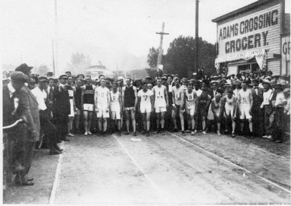 A photo shot in 1913, looking west, shows a footrace about to start on what engineers now call the "slip ramp" off westbound Colorado Avenue as it comes up to Columbia Road. The Adams Crossing Grocery at right is on the same site as the medical marijuana store today. The streetcar line can be seen in the roadbed. The line continued along the north side of Fountain Creek. Its former right of way is used now by the Midland Trail, with a fence between it and the Garden of the Gods RV Resort. Historian Mel McFarland has identified the large vehicle in the background (behind the runners) as a streetcar. Courtesy of Tom Daniels, from the Old Colorado City Historical Society Archives
|
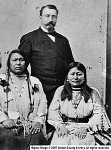 Charles Adams (standing), with Chief Ouray and his wife Chipeta in 1880 when a delegation of Ute Indians traveled to Washington to negotiate a treaty with the U.S. government. Courtesy of Uintah County Library and Clara Meury
|
In response to the information, the project team that's leading the bridge planning agreed at a public meeting this spring to name it the ōAdams Crossing Bridge.ö The idea was also supported by a broad show of hands from meeting attendees.
The $16 million project, funded mainly by voter-approved Pikes Peak Rural Transportation Authority funds, will also involve major upgrades down the avenue on either side of the bridge, between about 32nd Street and Manitou's Highway 24 interchange. Work is expected to start in September 2015.
The attention to Adams would seem appropriate. Even though he died in 1895, the surrounding area was known as ōAdams Crossingö for decades afterward - and a number of old-timers who've contacted the Westside Pioneer over the years still refer to it that way.
According to Tom Daniels, archivist for the Old Colorado City Historical Society (OCCHS), the name appeared in the past on official maps, postcards and as the name of a grocery store (at the corner where the medical marijuana shop is today). ōI'm sure if I dug around some more, I would find hundreds of references to 'Adams Crossing,' Daniels wrote in a 2012 e-mail to the multi-government project team planning the bridge/ avenue improvement project. ōEven the early telephone directories listed numbers in that area as 'Adams Crossing,' including my grandfather!ö
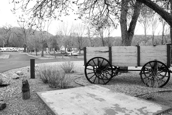 With an old-time wagon in the foreground as a historical reminder inside the Garden of the Gods RV Resort, a photo looking west shows the approximate area (roughly between the flag and the laundry building) where Charles Adams' house was. It was torn down in the 1960s, based on information from Chuck Murphy, who owned the property as the Garden of the Gods Campground for 38 years. Westside Pioneer photo
|
So who was Charles Adams?
He was famous in his time, owning a house and property near the creek/road crossing from 1879 until 1895 (when he was killed at age 55 in a Denver hotel fire). Among his accomplishments:
Nevertheless, there is no full biography of Adams, only bits and pieces from different sources. One notable gap in the legacy has been the location of Adams' Westside house. Even now, after the recent research, there's not quite an ōX marks the spot,ö but it's been narrowed down to a very small space inside the Garden of the Gods RV Resort, northwest of the Colorado/ Columbia intersection.
The recent historical turning point came when Mel McFarland, author of two books on the Midland railroads and columnist for local publications (including the Westside Pioneer), scrutinized two old photos of that area together. One was taken in 1953 (by then- Gazette photographer Stan Payne) and is the only known photo of the Adams house. At that time, the two-story,Victorian-style dwelling with a front porch was being used as the office for a camping business called Stonewall Cottages.
The other photo was a 1947 aerial view of that area. Because of the two photos' proximity in time, McFarland said he was able to correlate the cabins and trees in the background in the Payne photo with the same elements in the aerial view. Also of assistance, he said, was the accompanying Gazette article, written by Dorothy Aldridge, which described the house as northwest of the intersection. (Years later, Aldridge would write a book about the Westside: ōHistoric Colorado City: The Town with a Future.ö)
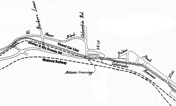 This 1917 track-layout map for the Interurban Railway Co. is from the 1983 book, "Pikes Peak Trolleys," by Morris Cafky and John A. Haney. The streetcar line and Denver & Rio Grande line going west converged at Columbia Road before the bridge, then followed what is now the Midland Trail route north of the avenue. Note that the location is identified as "Adams Crossing." (For clarity, the Westside Pioneer has added non-script identifiers for the streetcar and both rail lines.) Edited from "Pikes Peak Trolleys"
|
The Westside Pioneer followed up on McFarland's findings by contacting Chuck Murphy, who had owned, operated and expanded the Garden of the Gods Campground (now the RV Resort) from 1968 to 2006. In a phone interview, Murphy said he recalled having to tear down a two-story Victorian with a front porch because ōit was falling apart.ö The location he described, just west of the resort's current Events Center, matches the site McFarland identified.
The age of the many stone walls on the property is not known. Murphy said he believes they were built by the Works Progress Administration (WPA), a government program that paid people to work during the Depression years of the 1930s. However, McFarland has written that ōStonewall Parkö - one of the early automobile-oriented campgrounds - was on at least part of what's now the RV Resort property as early as 1922.
The crossing area must have looked a lot different in Adams' day. A west-facing 1926 photo, shot about a quarter-mile from the bridge, gives an idea. Some development is visible near the bridge itself, but leading up to it there are no motels yet, nor any kind of development on either side of the road. So it can be imagined how remote that area may have been, circa 1895.
Still, at that time, Adams Crossing itself would have had a fair amount of activity, with more actual ōcrossingsö than just the road over the creek. In 1880, the Denver & Rio Grande railroad line had been built from Colorado Springs to Manitou. Approaching the Colorado/Columbia bridge westbound, the line ran south of the avenue and north of Fountain Creek (roughly passing through where Amanda's Fonda is today). It then curved northwest, crossing the avenue just before the bridge, staying north of the creek.
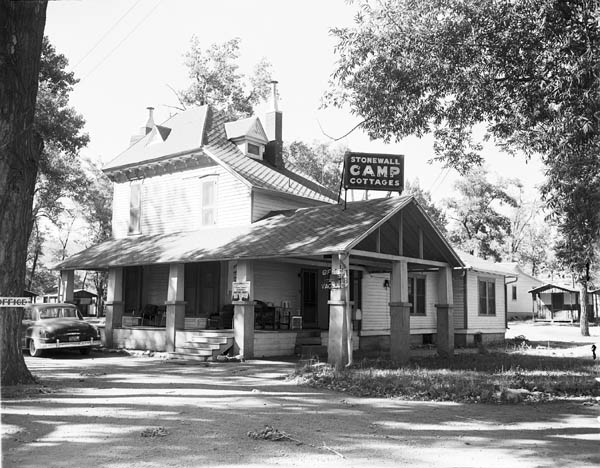 Charles Adams' house still stood in 1953. At the time, the place was used for a camping business called Stonewall Cottages. Courtesy of Pikes Peak Library District Special Collections 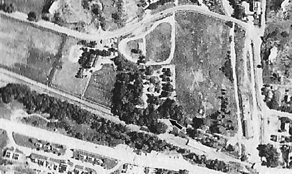 In a 1947 aerial view, an arrow (edited on) points to Adams' house. Note: North is up. The intersection of Colorado Avenue at Columbia Road, as well as the bridge over Fountain Creek, are partially in view at lower right. West of the bridge, the avenue is the wide thoroughfare at lower left. The right of way for the railroad and streetcar lines is north of the avenue and the creek (which is mostly obscured by vegetation). Courtesy of Mel McFarland
|
Then, in 1890, the Colorado Springs Rapid Transit Railway laid in a streetcar line from the Springs to Manitou. Its westbound approach to the crossing was along the avenue. Shortly before the bridge, it veered northwest and ran alongside (just north of) the D&RG line. A lasting effect was the avenue being wider for about 100 feet leading up to Columbia Road - what modern engineers sometimes call a ōslip-ramp.ö
Another local historian contributing to the recent Adams Crossing research was Clara Meury of Manitou Springs, whose assistance included supplying the photo of Charles Adams, corroborating parts of his background and providing the location of his gravesite in Manitou's Crystal Valley Cemetery.
Also consulted was long-time Westside historian and civic leader Dave Hughes, who provided the following input: ōWhile it was named for the crossover at Adams' home of Fountain Creek from the south side of Colorado Avenue to the north side, it today represents the crossover from Colorado Springs to Manitou Springs. And yes, a suitably large sign can tell the Adams history story, and the original reason for the name - Adams Crossing.ö
Westside Pioneer article
Note: Additional photos, along with articles discussing the engineering and public elements of the ōWestside Avenue Action Planö study preparing for next yearÆs $16 million project in the Adams Crossing area, can be found at the Westside PioneerÆs online site: westsidepioneer.com. They are archived in the 2014 Projects category, No ManÆs Land subcategory.