History meets present-day at Adams Crossing
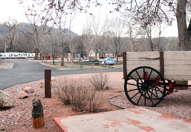 With an old-time wagon in the foreground as a historical reminder inside the Garden of the Gods RV Resort, a photo looking west shows the approximate area (roughly between the flag and the laundry building) where Charles Adams' house was built in the late 1800s. It was torn down in the 1960s, based on information from Chuck Murphy, who owned the property as the Garden of the Gods Campground for 38 years. Westside Pioneer photo
|
The attention would seem appropriate. Even though Adams died in 1895, the surrounding area was known as ōAdams Crossingö for decades afterward - and a number of old-timers who've contacted the Westside Pioneer over the years still refer to it that way.
According to Tom Daniels, archivist for the Old Colorado City Historical Society (OCCHS), the name appeared in the past on official maps, postcards and as the name of a grocery store (at the corner where the medical marijuana shop is today -- See separate Westside Pioneer article). ōI'm sure if I dug around some more, I would find hundreds of references to 'Adams Crossing,'ö Daniels wrote in a 2012 e-mail to the multi-government project team planning the $16-million bridge/avenue improvement project. ōEven the early telephone directories listed numbers in that area as 'Adams Crossing,' including my grandfather!ö
So who was Charles Adams?
He was famous in his time, owning a house and property near the creek/road crossing from 1879 until 1895 (when he was killed at age 55 in a Denver hotel fire). Among his accomplishments:
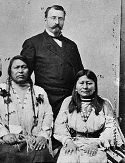 Charles Adams (standing) is shown with Chief Ouray and his wife Chipeta in 1880 when a delegation of Ute Indians traveled to Washington to negotiate a treaty with the U.S. government. Courtesy of Uintah County Library and
Clara Meury
|
- Immigrant from Germany (for political reasons, according to a 1953 article in the Gazette).
- Civil War veteran (shot in the lungs in the Battle of the Wilderness).
- Honorary general in the Colorado Militia after the war.
- Part of the investigation board in the case of Alferd Packer, the cannibal.
- Indian agent whose friendship with Chief Ouray and his wife Chipeta helped negotiate the release of hostages taken after the Meeker Massacre of 1879.
- Minister to Bolivia (1880-82) by appointment of President Hayes.
- Member of the board of directors of the Colorado City Glass Works and the Manitou mineral water company.
- Buried in Crystal Valley Cemetery with two gravestones (one stating his Civil War service, the other noting him as ōrescuer of the captive Meeker womenö).
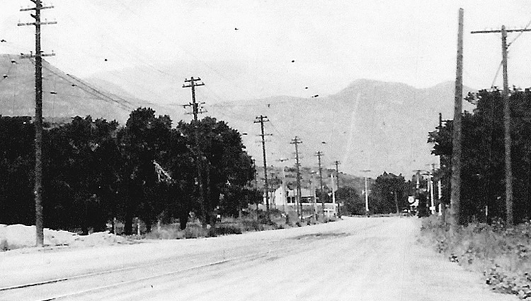 A photo shot in 1926 shows an unpaved Colorado Avenue, looking west with the bridge over Fountain Creek curving to the left in the background. Note the streetcar tracks in the roadbed and their wires overhead. Courtesy of Mel McFarland
|
Nevertheless, there is no full biography of Adams, only bits and pieces from different sources. One notable gap in the legacy has been the location of Adams' Westside house. Even now, after the recent research, there's not quite an ōX marks the spot.ö but it's been narrowed down to a very small space inside the Garden of the Gods RV Resort, northwest of the Colorado/Columbia intersection.
The turning point came when Mel McFarland, author of two books on the Midland railroads and columnist for local publications (including the Westside Pioneer), scrutinized two old photos of that area together. One was taken in 1953 (by then-Gazette photographer Stan Payne) and is the only known photo of the Adams house. At that time, the two-story, Victorian-style dwelling with a front porch was being used as the office for a camping business called Stonewall Cottages.
The other photo was a 1947 aerial view. Because of the two photos' proximity in time, McFarland said he was able to correlate the cabins and trees in the background in the Payne photo with the same elements in the aerial view. Also of help, he said, was the accompanying Gazette article, written by Dorothy Aldridge, which described the house as northwest of the intersection. (Years later, Aldridge would write a book about the Westside: ōHistoric Colorado City: The Town with a Future.ö)
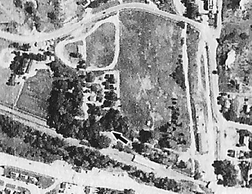 In a 1947 aerial view, an arrow (edited onto the photo) points to the location of Charles Adams' house, which was still standing at that time. Local historian Mel McFarland said he figured out the location with the help of details in the 1953 close-up of the house (lower on this page). Note: North is up. The intersection of Colorado Avenue at Columbia Road, as well as the bridge over Fountain Creek, are partially in view at lower right. The avenue west of the bridge is in the lower left. The right of way for the railroad and streetcar lines is north of the avenue, at a more northwesterly angle. Courtesy of Mel McFarland
|
The Westside Pioneer followed up on McFarland's findings by contacting Chuck Murphy, who had owned, operated and expanded the Garden of the Gods Campground (now the RV Resort) from 1968 to 2006. In a phone interview, Murphy said he recalled having to tear down a two-story Victorian with a front porch because "it was falling apart." The location he described, just west of the resort's current Events Center, matches the site McFarland identified.
The age of the many stone walls on the property is not known. Murphy said he believes they were built by the Works Progress Administration (WPA), a government program that paid people to work during the Depression years of the 1930s. However, McFarland has written about "Stonewall Park" -- one of the early automobile-oriented campgrounds -- on at least part of what's now the RV Resort property as early as 1922.
The crossing area must have looked a lot different in Adams' day. A west-facing 1926 photo, shot about a quarter-mile from the bridge, gives some idea. Some development is visible near the bridge itself, but leading up to it there are no motels yet, nor any kind of development on either side of the road. So it can be imagined how remote that area may have been, circa 1895.
Still, at that time, Adams Crossing itself would have had a fair amount of activity, with more actual ōcrossingsö than just the road over the creek. In 1880, the Denver & Rio Grande railroad line had been built from Colorado Springs to Manitou. Approaching the Colorado/Columbia bridge westbound, the line ran south of the avenue and north of Fountain Creek (roughly passing through where Amanda's Fonda is today). It then curved northwest, crossing the avenue just before the bridge, staying north of the creek.
Then, in 1890, the Colorado Springs Rapid Transit Railway laid in a streetcar line from the Springs to Manitou. Its westbound approach to the crossing was along the avenue. Shortly before the bridge, it veered northwest and ran alongside (just north of) the D&RG line. A lasting effect was the avenue being wider for about 100 feet leading up to Columbia Road -- what modern engineers refer to as a ōslip-ramp.ö
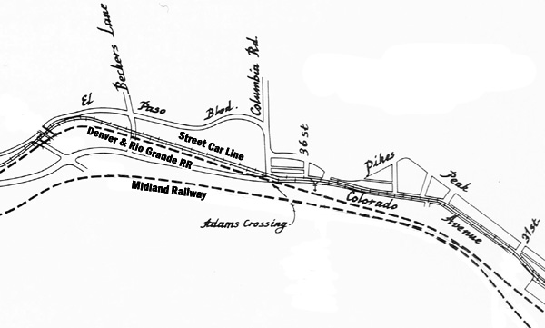 This is a slightly edited version of the map that appears in the book, "Pikes Peak Trolleys: A History of the Colorado Springs Streetcar System," by Morris Cafky and John A. Haney." The map in the book is titled "Track Layout, Colorado Springs and Interurban Railway Co., November 1917." The streetcar line and Denver & Rio Grande line going west can be seen converging at Columbia Road just before the bridge, then following the route of what is now the Midland Trail just north of the avenue and the creek. Note that the location is identified as "Adams Crossing." (The editing, done by the Westside Pioneer, adds non-script identifiers for the streetcar and both rail lines.) Edited from "Pikes Peak Trolleys"
|
With his house a couple hundred feet to the north of the train and streetcar lines, Charles Adams sitting on his front porch would have had a grand view of the rail activity, as well as horses and pedestrians moving along the then-unpaved avenue.
What did the bridge look like then? No photo or research has surfaced on that, although a city water map from 1917 [dug up by Daniels after the April 16 public meeting, leading to this paragraph being updated April 20] identifies it as a concrete bridge at that time (and that's probably the one that the current 1934 bridge replaced). See a copy of the map in the Westside Pioneer's coverage of the Adams Crossing matter at the April 16 meeting.
Adams' house must have seen interesting times. According to the Aldridge article, the man was ōfrequently playing host to numbers of Ute Indians on their way through the countryģ He and Mrs. Adams are said to have had the finest collection of Indian rugs in the region, thanks to the appreciation of the Indians.ö
Both the railroad and streetcar service ended by the 1930s, but some of the right of way remained. That is what the Midland Trail uses now, heading west of Columbia Road, just north of the creek.
Ian Horgan, general manager of Garden of the Gods RV Resort, expressed interest in the Adams history. In 2012, his company had bought the 13-acre site, offering cabins and RV and tent camping. Horgan said he is contemplating a display of some kind on site, so as to show tourists the history that had occurred there. He enjoyed the coincidence that a current building in the Adams-house area of the RV Resort also has "stonewall" in its name (a tie-back to the 1953 Stonewall Cottages photo).
Less interest is being shown currently by the multi-government team seeking to define the scope of improvements for that area. The team consists of engineers from three local governments (El Paso County, Colorado Springs and Manitou Springs) with a contracted consultant and its subconsultants. In 2012, lead consultant Steve Murray had told the Westside Pioneer it was possible, based on historical information then provided, that the bridge could be named the ōAdams Crossing Bridge.ö However, a conversation this week with Barry Grossman of Bachman PR, which handles the project team's public relations, revealed that the group has been told by a Pioneers Museum representative that Adams Crossing is of no significant historical importance.
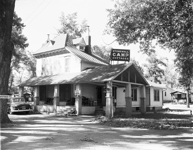 Charles Adams' house was still standing in 1953, as shown in this photo by then-Gazette photographer Stan Payne, accompanying an article by writer Dorothy Aldridge. At the time, the place was being used for a camping business called Stonewall Cottages. The photo caption in the article said that "the tallest portion of the house seen at left is the original building containing two upstairs rooms and an attic as well as storage space." The article added that Adams also built "several adjacent guest cottages, each containing a number of rooms, and a lean-to which served as a kitchen." Courtesy of Pikes Peak Library District
Special Collections
|
Daniels disagrees. "When you come right down to it, Charles Adams was a national figure,ö he wrote in an e-mail that has been provided to the project team. ōNot only did the governor of Colorado bestow the honorary general title to his name, but the president of the United States made him the ambassador to Bolivia. This is why I am pushing to keep the name of Adams Crossing tied to that area that's been called that for over 100 years. Someday, that area may be annexed into Manitou or Colorado Springs. But it can still be known to locals as Adams Crossing just as Colorado City is referred to today."
The next public meeting on the study planning will be Wednesday, April 16, from 5:30 to 7 p.m. at the Westside Community Center, 1628 W. Bijou St. See Westside Pioneer advance article.
Note: Another local historian contributing to the recent Adams Crossing research was Clara Meury of Manitou Springs, whose assistance included supplying the photo of Charles Adams, corroborating parts of his background and providing the location of his gravesite in Manitou's Crystal Valley Cemetery.
Also consulted was long-time Westside historian and civic leader Dave Hughes, who provided the following input: ōWhile it was named for the crossover at Adams' home of Fountain Creek from the south side of Colorado Avenue to the north side, it today represents the crossover from Colorado Springs to Manitou Springs. And yes, a suitably large sign can tell the Adams history story, and the original reason for the name -- Adams Crossing.ö
Westside Pioneer article
(Posted 4/11/14; updated 4/20/14;
Projects: No Man's Land)
Would you like to respond to this article? The Westside Pioneer welcomes letters at editor@westsidepioneer.com. (Click here for letter-writing criteria.)